|
|

|
Nautical activities |
Windsurf
Escola Windsurf
Avda. Mestral, 34 - Local 4
Phone: (+34) 685 19 81 93.
Snorkelling-apnoea
Centre d'Immersió
C.I.P.LL.
Castellar, 6
Phone: (+34) 972 12 14 00.
Rental
of vessels
Mar Brava Rent a Boat
Av. Europa - Local 4
Phone: (+34) 972 12 08 38
|
Kayaking
escola de piragüisme
La Farella, 25
Phone: (+34) 627 43 33 32.
Snorkelling-apnoea
Centre d'immersió
Cap de Creus
Pintor Martínez Lozano,
9
Phone: (+34) 972 12 00 00.
Catamaran
Escola de Windsurf
Avda. Mestral, 34 - Local 4
Phone: (+34) 685 19 81 93. |
Sailing
Club Nàutic
Moll Jordi Canal
Phone: (+34) 972 38 07 10.
Boat trips
Centre d'immersió
Cap de Creus
Pintor Martínez Lozano,
9
Phone: (+34) 972 12 00 00. |

| Walking
Routes |
|
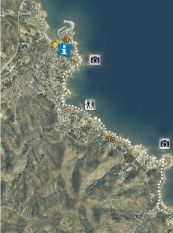
From
Llançà to Port de la Selva "El Camí
de Ronda" |
STARTING POINT: Port tourist office
POINT OF ARRIVAL :
Port tourist office
DIFFERENCE IN HEIGHT (metres)
: 50 m
TIME-LENGTH : 4h 45min.
GRADE OF DIFFICULTY : Low
TYPE OF TRACK : Road, walking-track
and wide-track
DESCRIPTION OF ITINERARY:
This path can be started from any
point and all our appartments are very close to it.
In particular, "Cau del Llop 1" has private
stairs leading directly from the terrace to the Pathway.
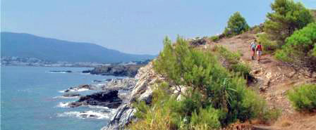
El "Camí de Ronda" is
the catalan name for the pathway that extends along
the coastline, from the port of Llançà
all the way to the next town, Port de la Selva. It serves
to walk to the different creeks of Llançà:
la Gola, Les Carboneres, playa Bonetti, La Farella,
Les Tonyines and Cau del Llop. For 4km the pathway is
paved 4 meter wide and has some benches to stop and
admire the fantastic view of the sea. It is a perfect
place to both practice footing or just take a nice walk.
SITES OF INTEREST: Creeks, Beaches, Nature
and sea sights. |
|
From Llançà
to Cap Ras along the sea |
STARTING POINT:
Port tourist office
POINT OF ARRIVAL : Port tourist
office
DIFFERENCE IN HEIGHT (metres): 30 m
TIME-LENGTH: 2h 45min.
GRADE OF DIFFICULTY : Low
TYPE OF TRACK : Road, walking-track and wide-track
DESCRIPTION OF ITINERARY:
From the Port tourist office, go
to the promenade towards the Sant Carles neighborhood.
From there, proceed toward the beaches of Sant Jordi,
Grifeu and Canyelles to reach cape Ras. Follow the seashore
and return the same way.
SITES OF INTEREST: Cape Ras, beaches |
|
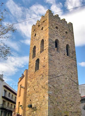
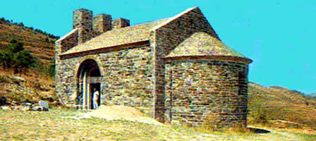
Mediaeval Llançà
|
STARTING POINT: The
tower on the village square
POINT OF ARRIVAL : The tower
on the village square
DIFFERENCE IN HEIGHT (metres): 100m
TIME-LENGTH: 1h 15min.
GRADE OF DIFFICULTY : Low
TYPE OF TRACK : Paved streets
DESCRIPTION OF ITINERARY:
From the town-square, proceed from
the tower to the Dins la Vila street, descend along
Muralla street and start to ascend along Afora, Pi and
Torre streets to the square where the windmill is; stop
at "l'era" (a square where there is a plaque
representing the Nature Reserve of Cape Creus), to observe
the hill of Damunt and the farmhouse of Gifre. Descend
along carrer Sant Vicenç to reach the old abbot's
palace (once owned by the abbot of the monastery of
Sant Pere de Rodes) and the church of Sant Vicenç.
From the street of Rafel Estela (old "carrer de
mar" or "sea street") and Picasso, one
reaches the defense tower, having crossed a car park
and the back of the Casa de Cultura grounds.
 SITES
OF INTEREST: Tower of the town-square, Tree
of Freedom, New Church (Sant Vicenç), Muralla
street, Windmill, abbot's palace. |
|
Falcó fountain |
STARTING POINT:
Port tourist office
POINT OF ARRIVAL : Port tourist office
DIFFERENCE IN HEIGHT (metres): 25 m
TIME-LENGTH:1h 45min.
GRADE OF DIFFICULTY : Low
TYPE OF TRACK : Paved road, wide-track and walking-track
DESCRIPTION OF ITINERARY:
Leave the Port tourist office and
go toward the village. From the port chapel go toward
Gardissó street (via Estela street), proceeding
to the schools, from where you ascend toward the fountain
of Falcó (behind the institute). From the fountain,
enter to Llebeig street. Follow the walking track that
leads to platja de les Tonyines (the "beach of
the tunas") and then take the camí de ronda
GR-92 (track along the seashore). This is a particularly
beautiful walk, with wonderful views of the coast. Walk
along the beaches of Farella, Carboneres, past Gola
and Castellar, to reach the Port of Llançà,
about a km out of town.
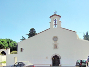
SITES OF INTEREST : Port Chapel, Fountain
of Falcó, beaches and small coves, el Castellar
and the Port area.
|
|
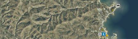
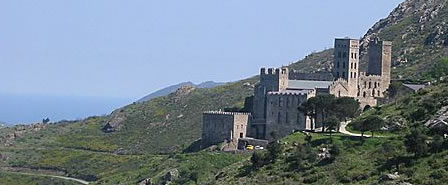
Old track to the Monastery of Sant
Pere de Rodes |
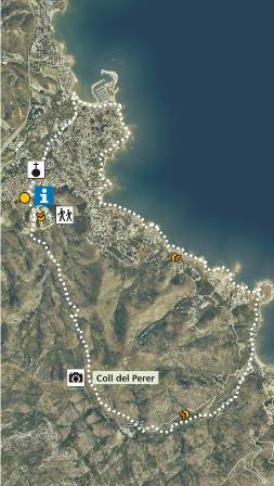
STARTING POINT:
Tourist office
POINT OF ARRIVAL : Tourist office
DIFFERENCE IN HEIGHT (metres): 409 m (Coll del
Perer)
TIME-LENGTH: 4h 15min.
GRADE OF DIFFICULTY : Medium
to high.
TYPE OF TRACK : Wide-track, cart-track and walking-track
DESCRIPTION OF ITINERARY: Leave from
the tourist office, direction coll del Perer.
Immediately
follow a wide-track that leads to ribera d'en Prim (Prim's
stream). Cross the stream and climb the hill toward
coll del Perer (mountain pass). Descend to the hamlet
of Vall de Santa Creu and eventually to the beach along
the track next to the stream. Return along the GR-92,
following this walking-track along the shore, to Llançà.
Once in the Port go toward the village to reach the
tourist office.
RECOMMENDATIONS: Wear good footwear;
fitness required.
SITES OF INTEREST:
Tower on the town-square, Ribera
d'en Prim (stream), medieval cart-track, vineyard-sheds,
Coll Perer viewing platform, Vall de Santa Creu.
|
|
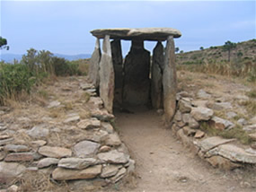
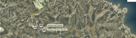
For prehistory lovers (Dolmens and Menhirs) |
Dolmen Roca
Miralles |
STARTING POINT: Road
from Llançà to Figueres Km 20,8.
POINT OF ARRIVAL : Road from
Llançà to Figueres Km 20,8.
DIFFERENCE IN HEIGHT (metres):
100m
TIME-LENGTH: 30 min.(walk from the road to the
dolmen)
GRADE OF DIFFICULTY : Medium
TYPE OF TRACK :Walking-track.
DESCRIPTION OF ITINERARY :
Take the road from Llançà
to Figueres and once past the railway-bridge, turn left
down a track (aproximately on Km 20,8). Follow this
track toward mas Pujolar (farmhouse) Past the farmhouse,
the track runs along the flank of the Roca Miralles
hill and leads straight to the dolmen.
SITES OF INTEREST Dolmen of Roca Miralles
|
|
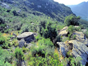
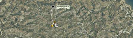
Dolmen Mas
de la Mata |
STARTING POINT : Road
of Sant Pere de Roda-Vilajuïga Km 1,5.
POINT OF ARRIVAL : Road of Sant Pere
de Roda-Vilajuïga Km 1,5.
DIFFERENCE IN HEIGHT (metres):70
m
TIME-LENGTH: 1 h. (one-way)
GRADE OF DIFFICULTY : Low
TYPE OF TRACK : Road and wide-track
DESCRIPTION OF ITINERARY:
Take the road that goes from the
monastery of Sant Pere de Rodes to Vilajuïga; after
approximately one and a half kilometres, turn right
down a wide-track to mas Margall (a farmhouse). Go past
the farmhouse leaving it on the right-hand side and
go up the track on the left hand-side to the house called
can Magí. From here, descend to the farmhouse
of mas de la Mata. The dolmen can be found on the North
side.
SITES OF INTEREST : Dolmen of Mas de
la Mata
|
|
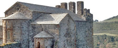
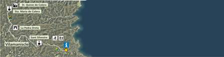
From Llançà
to Puig d'Esquers and Sant Quirze de Colera |
STARTING POINT :
Tourist office
POINT OF ARRIVAL : Sant Quirze de Colera
DIFFERENCE IN HEIGHT (metres): 220 m
TIME-LENGTH: 2 h.
GRADE OF DIFFICULTY : Medium
TYPE OF TRACK : Wide-track and walking-track.
DESCRIPTION OF ITINERARY:
From the tourist office, go toward
Sant Silvestre. Follow the GR-11 track until Vilamaniscle,
from where the signs on the track lead toward Sant Quirze
de Colera. After approximately 1,5 Km, there is the
menhir or standing stone of Mas Roqué. Continue
to the abbey of Sant Quirze de Colera; to the West and
not far away, the romanesque church of Santa Maria can
also be seen.
SITES OF INTEREST : The standing stone,
Sant Quirze de Colera, Sant Pere de Besalú, Santa
Maria de Colera.
|
|
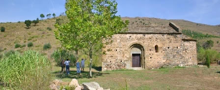
From Llançà
to Puig d'Esquers and Sant Miquel de Colera |
POINT OF ARRIVAL : Tourist office
DIFFERENCE IN HEIGHT (metres): 605 m
TIME-LENGTH: 6h.
GRADE OF DIFFICULTY : Medium to high.
TYPE OF TRACK : Wide-track and walking-track.
DESCRIPTION OF ITINERARY:
From the tourist office, go toward
Sant Silvestre. Follow the GR-11 and leave it when reaching
mas Guanter (farmhouse), just below the hill of Esquers
(if you continue along the GR-11, you will be following
itinerary 2.1 "Hill of Esquers"). Half-way
up, turn to the left to visit the chapel of Sant Martí
de Vallmala; return along the same track to continue
the route. Once on the hill of Esquers, enjoy the views
and visit the dolmen. On the descent, turn left to reach
Sant Miquel de Colera, and return along the same track
to reach the cross-roads and continue with the itinerary.
Follow the summit along the puig del Llop ("Wolf's
hill") and Tifell hill, where the Tifell dolmen
can be visited. Continue descending along the hill-range
of Socarrador until Argilera, from where you can reach
the Port walking along the seaside. Once in the Port,
go toward the village to reach the departure point.
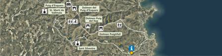
SITES OF INTEREST :Sant Silvestre de
Valleta, Sant Martí de Vallmala, Puig d'Esquers,
Dolmen of Puig d'Esquers, Sant Miquel de Colera.
|
|
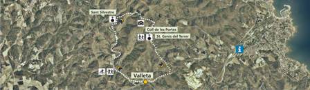
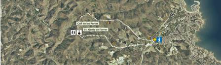
From Valleta to
Sant Silvestre and Sant Genís |
STARTING POINT :
Valleta
POINT OF ARRIVAL : Valleta
DIFFERENCE IN HEIGHT (metres): 270
m
TIME-LENGTH: 2h.
GRADE OF DIFFICULTY : Medium
TYPE OF TRACK : Wide-track
DESCRIPTION OF ITINERARY:
From Valleta, take the track that
climbsby the stream of Valleta to Sant Silvestre. Once
at the church, proceed toward Coll de les Portes (Portes
mountain pass). Before reaching the top, theree is the
option of taking the track that goes to the dolmen of
Puig del Llop. If taking this option, one must then
return the same way to continue the itinerary. Once
at the top, on Coll de les Portes, take the way that
descends toward Sant Genís del Terrer. Follow
the summit along clot de Valletato reach the newly urbanized
area.
SITES OF INTEREST : Sant Silvestre de
Valleta, Dolmen of Puig del Llop (the "Wolf's Hill"),
Sant Genís del Terrer, Valleta
|
|
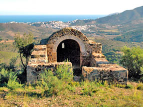
From Llançà
to Sant Genís del Terrer |
STARTING POINT :
Tourist office
POINT OF ARRIVAL : Tourist office
DIFFERENCE IN HEIGHT (metres):
200m
TIME-LENGTH: 2h.
GRADE OF DIFFICULTY : Medium
TYPE OF TRACK : Wide-track and walking-track
DESCRIPTION OF ITINERARY :
From the tourist office, turn towards
the stream. Cross the stream and climb toward a wide-track
that leads to the Coll de les Portes. From there descend
to Sant Genís del Terrer to join the track that
goes down along the Terrols stream, heading back to
the N-II main road and to the tourist office.
SITES OF INTEREST :Coll de les Portes,
Sant Genís del Terrer.
|
|
|